HYDROLOGY MADE SEXY
Introduction
Angkor is an amazing place. You cannot fail to be impressed even stunned by the grandeur, detail and scale of the monuments. The true wonder of the Angkorian Empire and what it had achieved only started to dawn on me in the last few years. It was when the findings of the Lidar survey were published that I grasped the extent of what was one of the world’s greatest civilisations.
Lidar in layman terms emits an electromagnetic pulse – a laser that is strapped to a helicopter and fired as it passes over the ground to be surveyed. The reflected light is fed through software that strips away the vegetation to reveal the topography and previously unidentified structures.
The results are phenomenal! Phnom Kulen had a city on top. Angkor Thom was laid out in a grid of roads and canals framing wooden houses and their trapaeng or pools. There were thousands of temples not hundreds, and it was all made possible by the management of water in a climate where at the best of times 6 months of rain is followed by 6 months of drought.
I also began to realise that many of our cycle routes, hiking trails and even kayaking adventures followed these ancient waterways. I’d heard Roland Fletcher give fascinating talks at the Amansara Resort and on the banks of the West Baray. It wasn’t until Damian Evans (also from Sydney University) spoke to the guides I was managing that I knew he could tell us what we needed to understand Angkor.
The Water Connection
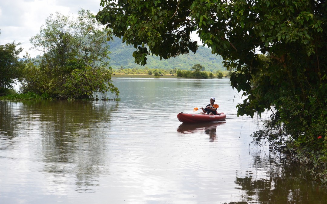
Boeung Ta Neue – our Secret Lake where we kayak, was an Angkorian reservoir formed by an extension of the North Wall of the East Baray, a much larger reservoir connected with the Angkorian cities of Ta Prohm and Angkor Thom. Boeung Ta Neue caught the rain run off from the
Kulen Hills to the North, which fed the Baray and in turn the conurbations of Angkor.
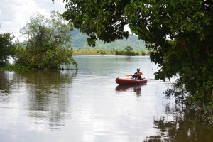 Kayaking on Boeung Ta Neue Angkorian Reservoir (Secret Lake)
Nearby where the Baray finishes and the wall extension starts, is the 7 arched Spean Tor Bridge. Clearly visible by kayak from the water, we managed to reach it through the bush from the red earth road where Damian* had parked.
*Damian Evans archeologist working for Sydney University
We searched on the Baray side of the road for an exit but with none to be seen we couldn’t work out the purpose of the bridge though to be sure a thousand years ago it had one.
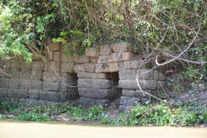 Spean Toh Bridge (named after the nearby temple Prasat Toh
The main water flow into and out of the East Baray was through Kral Romeas, a sluice built into the banks of the East Wall. Cycling and hiking through Phum Samre, the village that lines the walls I’d noticed large laterite blocks and dismissed them as scattered from some Angkorian ruin, which they were. Closer inspection revealed 1 large thick wall and 30 metres away another running parallel forming two sides of the sluice. The raised ground in front of us was a laterite weir. Kral Romeas depending on time of year and water level, acted as an inlet and outlet to the East Baray and may have been connected by another laterite wall running parallel with the East Bank, to Boeung Ta Neue via Spean Toh.
An outlet has also been discovered opposite in the West Bank of the Baray, which fed into the Ta Prohm moat and then onto Angkor Thom. The East Baray at 14 square kilometers, 7km long and 2km wide would have supplied water to the two cities of Ta Prohm, Angkor Thom as well as the houses in between. It would also have been used for irrigation.
Damian explained the scale by comparing the East with the West Baray of similar size containing 50 million litre3 in the West Baray which provided irrigation for 5000 ha of rice, perhaps 10,000 tonnes for each crop. Feeding a population of hundreds of thousands of priests, the aristocracy and merchants who lived in and around these temple cities.
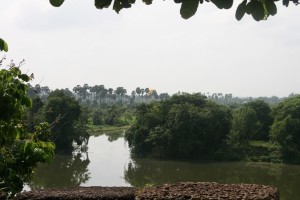
 The West Baray at the end of the rainy season
It was also unlikely that the 3 great water reservoirs of the West, East and North Barays were in simultaneous use but acted as a stabilising backup during times of drought and flood.
The scale of these man made hydraulics are unparalleled in human history and truly mind-boggling. The 3 spatial dimensions have to be combined with a 4th chronological dimension as the kings and climate changed over time. History seems to have been determined as much by the weather as the peaks in the empire. First during the reign of Suryavarman II in the 12th century then under Jayavarman VII in the 13th century, which coincided with the peaks in rainfall we saw from the ancient records on Damian’s computer screen and heralded the construction of the great temples of Angkor.
It is now suggested that the ultimate decline of Angkor was linked to periods of extreme drought followed by floods, which washed away the channels needed to supply water during the dry season. This is most clearly seen at Spean Thmor between Ta Keo and Angkor Thom where the old bridge lies high up the banks of the river now running meters below.
An as yet unexplained mystery is the adjacent 10 x 10 grid of a 100 mounds a few hundred meters from Prasat Toh. Similar grids have been found beside the ‘River of a Thousand Linga’s’ at Kbal Spean and Sambor Prei Kup near Kampong Thom, both associated with major water systems. No artifacts or remains have been found at either site that give any clues as to what the mounds are.
Walking through the site with Damian we spotted fragments of curved roof tiles in a papaya plantation that in an act of unintended vandalism, has been planted right over the mounds.
Most of what is known about Prasat Toh comes from a 4 sided stele (a stone pillar with carved enscriptions) discovered by the French in the 1930’s and now stored in The Angkor Centre for Conservation in Siem Reap. The Sanskrit engravings were translated and available on line. They explained that the stele had been installed by a Brahmin priest during the 13th century and referred to the Great King Jayavarman VII. The inscription mentions the Ganges River in association with water, which may have had something to do with the Kral Romeas sluice and was the same as an inscription found at Phnom Dai temple to the North, the site of another grid of mounds. The temple itself appears to predate the stele and is maybe contemporary with the 10th century East Baray.
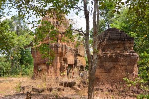 Prasat Toh and its 3 laterite towers situated near the North West corner of the East Baray
Randomly cast on the ground were the now eroded but once richly carved sandstone blocks that had adorned the structure including the stone crown that sat atop the central tower. Interestingly it had a hole in the middle, where a bronze finial in the form of a trident could have been positioned. Possibly removed at certain auspicious times of the year to bathe the Goddess Shiva sitting 15 meters below in sunlight.
Set amongst brilliant green paddy fields on the other side of Beoung Ta Neue is Leak Neang or Hidden Lady Temple. Dated to the 10th century and built at the same time as the spectacular brick temple of Preah Rup. A stele, which may give some clues to its origins has transferred to the Angkor Conservation for translation.
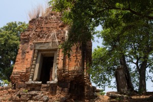 Leak Neang with its single brick tower
The bricks used in the construction of the structure are themselves a mystery as no kiln has ever been found. A theory speculates that the bricks were fired in a dedicated kiln close to the temples made of bricks, which were also used. The apparent black scorching seen on the walls seemed to support this idea.
Not only was this masterly management of water used to supply The Angkorians and irrigate their crops, it also conveyed the enormous amount of stone required to build the temples. Laterite is an iron rich clay that is soft and easy to dress into blocks when it comes out of the ground. On exposure to the sun it becomes very hard but relatively light making it ideal for the foundations but not the decoration as its pock-marked surface is not easily carved. The laterite quarries lay in the hills to the North West. Dams collected water from streams which was released into the Great North Channel that carried the stone blocks South to the North Baray from where they were used in the construction of Angkor.
At the Eastern end of the Kulen escarpment were quarries that supplied the sandstone, which was carved into the marvelous facades of the temples. As part of this network another channel ran from Beng Melea near the Eastern Kulen escarpment, past the Temples of Banteay Ampil and Chau Srey Vibol to Prasat Batchum inside Angkor Park. A path still connects these sites and makes for a great cycle ride.
We were beginning to get a handle on the Eastern end of the water connection, now it was time to explore the West. The Siem Reap River flows South from the Kulen Hills to the city and then onto the Tonle Sap Great Lake but during Angkor it was diverted into the North East corner of the Angkor Thom Moat. History is being repeated as subsequent to the floods of 2011 the channels have been reopened and another dug in parallel on the North side of the moat as the river is diverted into the West Baray with the aim of stopping the floods in Siem Reap. The fact that now the town of Puok to the West floods instead is not part of the discussion – tourists don’t go there.
Angkor Thom the largest of all the Angkorian Cities, was the capitol under Jayavarman VII. its wall’s 3km long enclose 900 hectares or 9 km2. Now forested but once the site of a thriving metropolis of wooden houses and trapeang (pools), surrounded by a grid of canals and roads as the Lidar survey revealed.
 View over the moat from the walls at the S.E corner of Angkor Thom
The data was detailed enough to show the individual houses, which can be extrapolated to give a guessed population of 70,000 based on an assumed family size. This would need a lot of water but during the rainy season any excess flowed out of Boeung Thom reservoir in the South West of Angkor Thom and through Runta Dev a canal that runs under the walls of the city into the moat. We’ve got a stunning cycle route that runs along the 8m high walls of Angkor Thom to Prasat Chrung or corner temple. A great late afternoon spot for watching the sun set over the moat, paddy fields and palm trees beyond. We didn’t realise the engineering marvel that lay 8 meters below us until Damian lead us down the inner banks to a stream that on closer inspection disappeared into a laterite tunnel under the walls and out to the glinting light of the moat 30m away.
The West Baray 500m to the West is yet another mystery. How was this vast body of water replenished and released during times of flood? The current outlet of the Angkor Thom moat is a canal running parallel with the road through the West Gate dug by the French, which destroyed any trace of what was there before. It is possible it was a replacement otherwise how did 50 million litres of water get into The Baray?
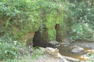 Runta Dev runs under the walls of Angkor Thom
What had we learnt that morning?
We understood that water running off the Kulen Hills to the North fed streams, which flowed into the reservoir of Beoung Ta Neue in turn feeding the East Baray, which was a water supply for the population of Angkor Thom and Ta Prohm.
Damian confirmed that our cycling path to Chau Srei Vibol and on to Banteay Ampil, lay along the route a canal had taken bringing sandstone from the quarries at the Eastern end of the Kulen escarpment via Beng Melea to Angkor.
He explained how the laterite blocks used to build the foundations of the Jayavarman VII temples were carried by water released into the Great North Canal which flowed from the quarries at the Western End of the Kulen Hills to the North Baray and father temple of Preah Khan.
And the Western hydrological connection was made by the Siem Reap River coming from the Western end of Kulen flowing into the Angkor Thom moat and maybe on into the West Baray.
And much else besides!
With great thanks to Damian Evans for a really fascinating morning and apologies for any misinterpretations.
Indochine Exploration with Smiling Albino Cambodia is pleased to take our guests on a introductory investigation of the main temples along the water courses described or an adventure to experience this incredible landscape on foot, by bicycle or kayaking.